Both routine and checklists are important pillars of flight safety and contribute to the stressless fun of flying. The daily weather briefing is a part of this routine.
But what should be included in a daily weather briefing?
We asked this question to many aircraft pilots, then confronted their answers with our meteorological knowledge. The result is a step-by-step typical weather briefing scheme which makes sure that nothing important will be left aside.
For those who want to skip the detailed instructions and want to jump directly to the PDF:
A weather briefing is a meteorological flight planning for aircraft pilots.
It is part of the flight planning and includes three steps:
The medium- or long-term weather briefing covering 3 to 6 days before the flight takes place.
The short-term weather briefing the day before or on the very same day of the scheduled flight
The debriefing after the flight where the real weather will be analysed and compared with the forecast to appreciate eventual improvement potentials. It should take place latest two days after the flight has been completed.
The following presentation focuses on the second step: The short term weather briefing immediately before the flight.
Why do I need a weather briefing ?
Training for weather forecast is part of the general skill acquisition for pilots and a weather forecast inquiry is mandatory before each flight.
This obligation is part of the European Directive (EU) N° 923/2012 (SERA), keyword SEA 2010. Stichwort SERA.2010, (ehemals der §3a LuftVO).
Different aviation activities require specific weather briefings because optimal weather conditions differ according to aircraft categories and aircraft types.
Gliders and paragliders rely on natural lift to gain altitude and stay aloft. Paragliders and delta wings need relatively quiet conditions with medium strength thermals in a limited area, while gliders need to collect weather information over much wider areas to cover much greater distances, sometimes over 1.000 km.
Powered aircraft however do not rely on any form of natural lift but would rather seek low turbulence conditions or routes allowing to save fuel.
It remains of utmost importance that weather forecast should be considered and handled with greatest care and respect, as an essential component of flight safety.
The short-term weather briefing, just before take-off
The short-term weather or morning briefing is taking place in the morning of the flight day, as well as just before take-off. The morning briefing is the most detailed one and decides whether the scheduled flight can be performed.
Weather forecasts of the previous day may have been subject to slight changes during the night according to more or less fast evolutions. The take-off location, the scheduled route, personal preferences, and other details may then be reconsidered as well.
A final briefing just before scheduled take-off time or just after will be considered if the conditions start changing faster as forecasted.
The following pages explain how to perform the detailed briefing on the day of the flight.
Ready? Let’s go.
How do I perform a weather briefing step by step?
There are many ways to prepare for your flight weather.
We wanted to know how you conduct your briefing – so we asked this question of numerous pilots to get a good overview of the main steps.
We then added our meteorological knowledge, and came up with the following step-by-step-guide:
1. Gain an overview of the present weather situation
If the weather evolution has been observed throughout the past few days, the information should be checked, and the changes identified in order to form an opinion on the general evolution of the conditions.
In European airspace, this includes satellite radar images and films, including the weather radar and the lightning map.
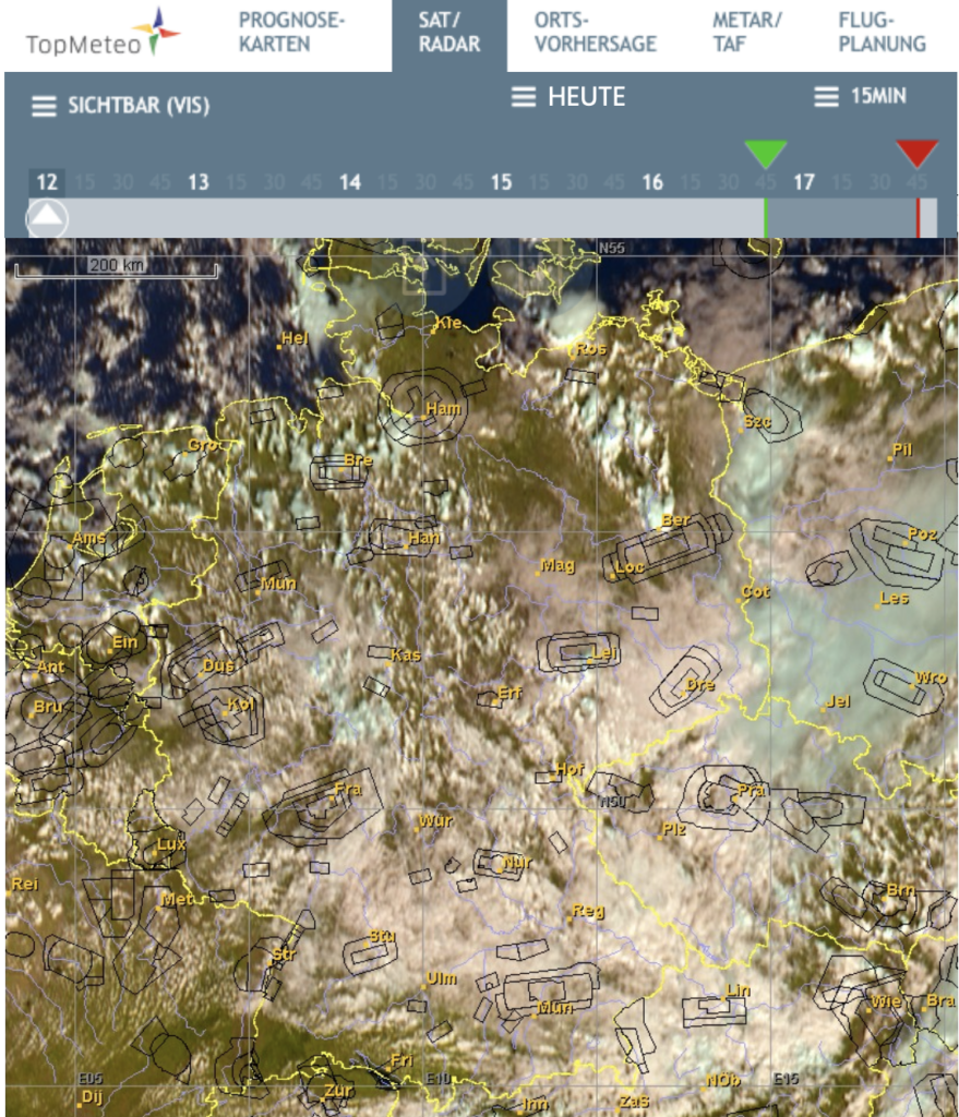
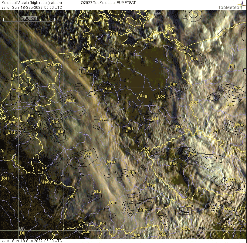
Satellite radar pictures : visual / night (VIS)
For a rough overview, we recommend you take a look at the satellite images and films. They show the extension and location of cloud clusters on large scale as well as their probable development.
Sichtbar (VIS) TopMeteo
These pictures can be accessed via the “ SAT/RADAR” menu in TopMeteo, either the “ visible “ or the “ night “ pictures.
Light colorations allow to identify low layer clouds (light yellowish) and high reaching ones in plain white. High reaching clouds can be for instance cirrus clouds or cumulonimbus anvils which can be easily identified by their shape and repartition.
Possible interpretations :
High altitude clouds (cirrus, Cb’s) can foreshadow rain.
Low layer clouds, like scattered cumulus, can reveal thermal activity.
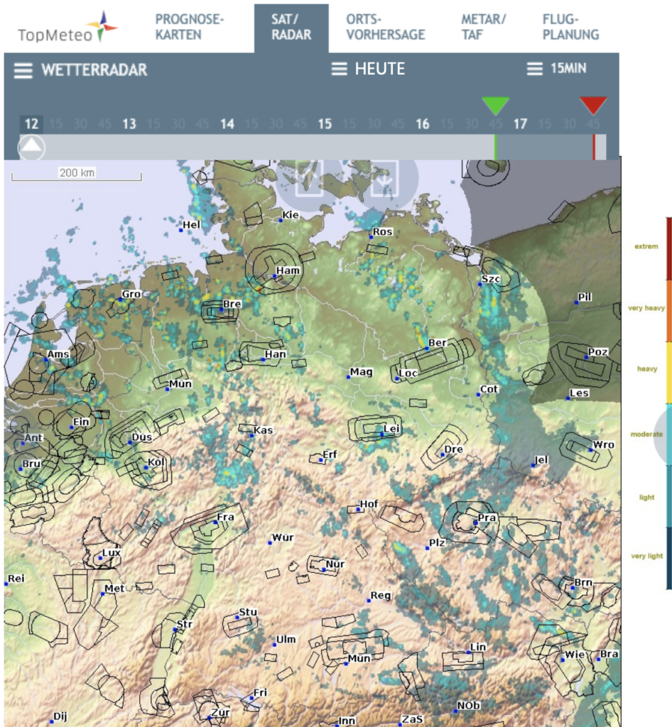
The weather radar
The weather radar map shows the current rain. It usually matches with the high-altitude clouds visible on the satellite pictures (VIS).
Wetterradar
This map can be also found under the “SAT/RADAR“ menu.
The colour scale shown on the right side of the map is matching the rain intensity. On the above picture, weak to medium intensity rain can be observed.
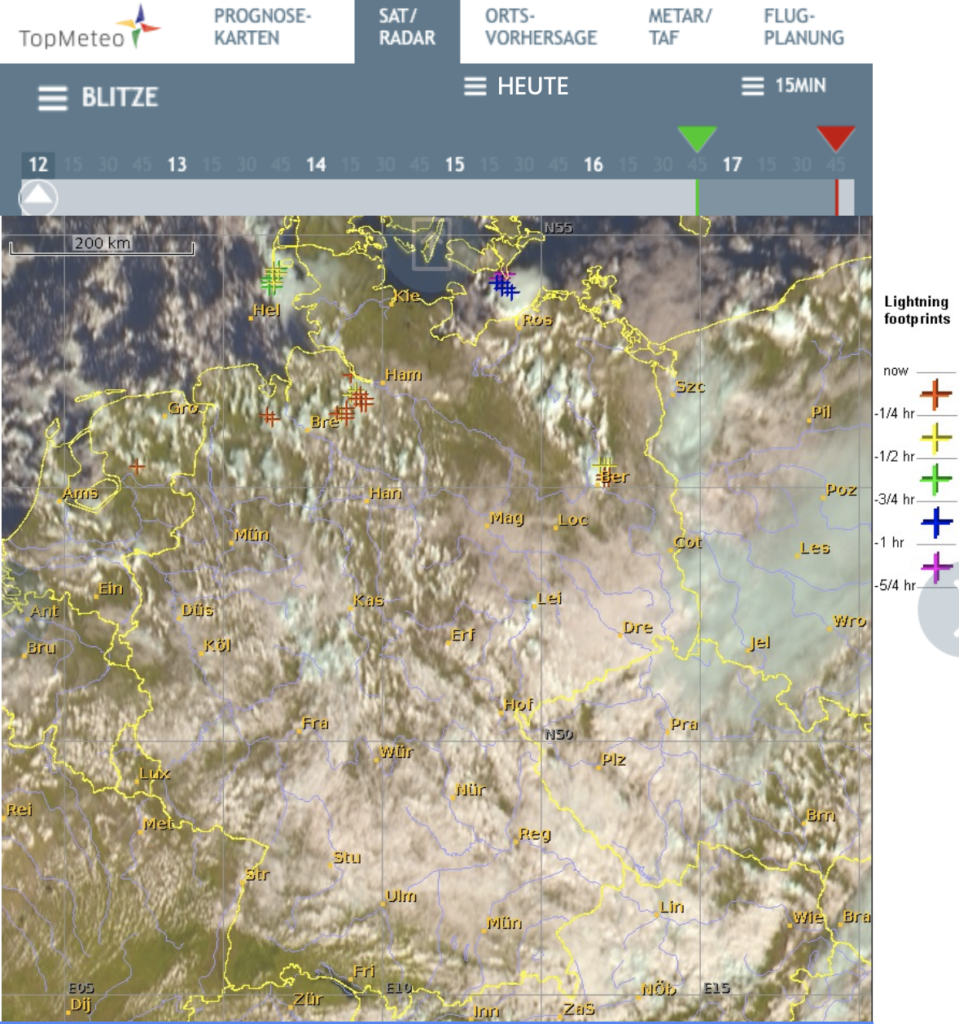
Lightnings
This map shows the upcoming of lightnings in real time. We recommend looking at this chart when high altitude clouds are shown on the satellite pictures.
Blitze-Karte TopMeteo
This map is also located in the “SAT/RADAR“ menu.
The markings show the locations of upcoming lightnings and the time elapsed since their occurrence according to the colours of the markings. In the above picture, in the south of the city of Hamburg.
Tops and bases of clouds
For vertical estimation of clouds in the airspace, the cloud tops and bottoms map is suitable.
Wolkenhöhen und Wolkenuntergrenzen-Karte TopMeteo
The numbers stand for the summits expressed in flight level and are also coloured. When the numbers are white, the summits are below FL 50. The symbols under the numbers stand for the cloud bases. The more red, the lower. The absence of numbers or symbols indicates cloudless skies.
The example on the map shows critical VFR conditions over medium heigth mountaineous areas, especially over the Erz. Thunderstorms south of Hamburg can still be bypassed. A glance at this map is of utmost importance just before take-off.
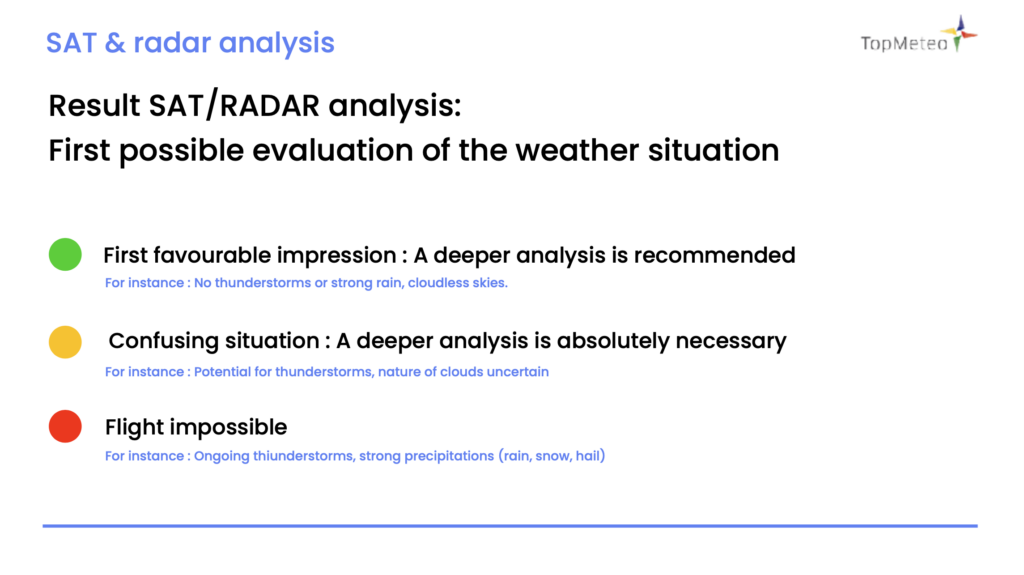
Result: The opportunity to form a personal opinion on the situation.
After these four overview maps you can now make a first personal assessment of the situation:
Result SAT:RADAR analysis
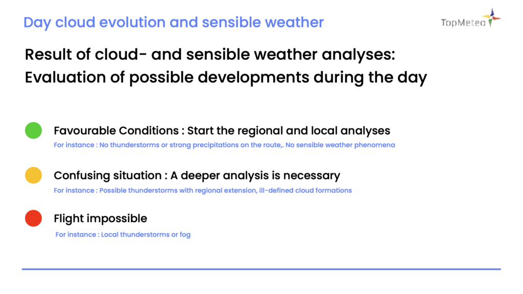
2. Evolution during the day and sensible weather (forecast)
If the evolution of the cloud formations has not been observed in the first step, it is now time to do it in order to build-up an estimation. This is what we call the weather forecast.
Weather forecasts are estimations produced by scientific weather models and are never 100% accurate. This is due to the extreme complexity of weather phenomena and one can never be sure that the forecast will fully match with reality.
However, the forecasting models are nowadays precise enough and offer precious help for short-term prediction.
As a matter of principle, stable weather situations (Omega situation for instance) allow a better forecast reliability than dynamic situations.
Evolution of cloud clusters during the day (video editing of satellite imagery)
To estimate whether your planned route, which looks good at takeoff, is also flyable during the course of the day, it helps to take a look at the satellite imagery.
This shows you when weather phenomena may affect your route.
Satellitenbild-animation TopMeteo
Sensible weather
In the second step, a deeper analysis of the cloud clusters which could prevent or interfere with the scheduled flight must be performed.
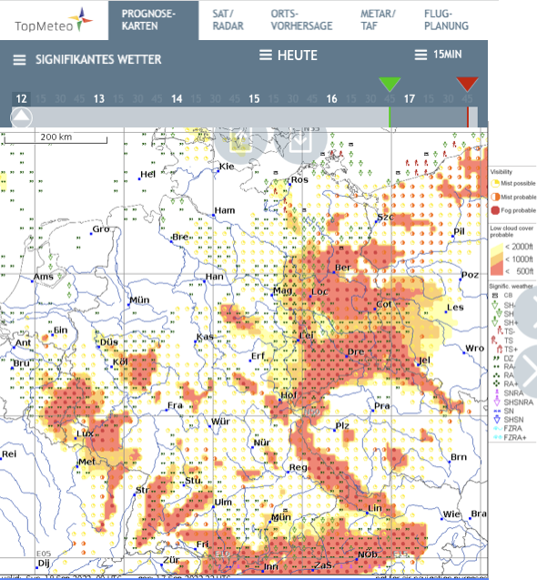
In the TopMeteo menu “forecast maps”, maps showing the sensible weather can be found.
Signikantes Wetter (Prognosekarten) TopMeteo
The above example shows easily identifiable cloud covers dragging at less than 500 ft as well as fog banks over East and South Germany. Those will limit the visibility; therefore greatest care is required.
More detailed analysis must be performed locally or regionally.
Use the following maps:
Fog analysis
Convection map (Thermals)
Front courses map at ground level
Result: Opportunity to set-up a forecast of the day evolution
After analyzing the weather during the day, you can make an assessment on the forecast.
Day cloud evolution and sensible weather
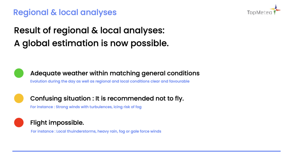
3. Regional und local analysis (flight route)
This is where it gets concrete: Based on your planned flight route, you look at the regional and local weather accordingly.
This is an important step, valid for flight travel as well as for local flying.
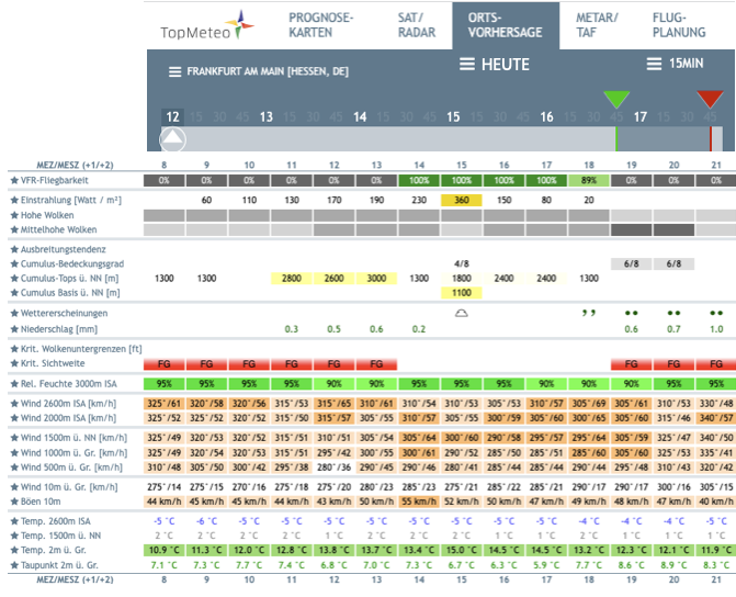
Local forecasts
For accurate local weather analysis, the local forecast is recommended. It is a separate menu item in TopMeteo and refers – as the name suggests – to the location entered.
Enter the starting point (airfield or city), stopovers and landing point (destination airfield) according to your flight route.
Ortsvorhersage TopMeteo
In this example, we have selected Frankfurt/Main. For the respective location you get corresponding values in the course of the day, such as:
VFR possible or not
Windspeed and direction on ground and in altitude
Tops and bases of clouds
Visibility
Precipitations
Temperatures
Sunrise and sunset time
Result: Opportunity to obtain a complete forecast of the weather situation.
After the regional and local analysis during the day, you can now make your overall assessment and decide if and how to fly.
Result of regional & local analyses: A global estimation possible
If the weather is flyable, you’ll probably get going, get your aircraft ready for take-off and inform eventual passengers.
However, it is always advisable to have a glance at the most recent satellite picture just before take-off.
For this, TopMeteo has developed the “TopMetSat” application for phones and tablets.
With this application you can wathc the latest satellite pictures in real time, even with a weak signal or a narrow bandwidth.
The takeaway weather briefing (download of the PDF document)
We have drafted this operating manual in PDF format to provide the opportunity to perform this briefing at any place, completely and without overseeing any point.