For all glider pilots who are enthusiastic about wave flight (mountain wave flights): TopMeteo provides mountain wave charts for optimal flight preparation. In this article you will learn how to prepare for the flight, how the analysis works and what mountain waves are.
What are mountain waves?
Mountain waves are stationary gravity waves that develop in the airflow on the lee side of mountains.
The parts of the wave that represent updrafts are a way for gliders to gain altitude.
For other aircraft such as balloons, hang gliders and paragliders, mountain waves are more of a hazard. In particular, lee wave rotors present severe turbulence and are thus also dangerous for commercial aircraft.
When flying through mountain waves (especially in the lee roll area) with an aircraft, occupants may perceive lee waves as an air pocket.
How do mountain waves develop and how can they be recognized?
Mountain waves typically occur in areas where strong winds frequently cross mountain ranges (e.g., eastern escarpment of the Sierra Nevada mountain range U.S.). They occur in groups and often together with an air vortex called a lee roll, rotor, or vortex roll.
Both the lee waves and the rotor, whose vortex axis is horizontal, are often accompanied by characteristic stationary cloud formations:
- lenticularis (also called blowfish) at the apex of the wave
- cumulus fractus in the ascending part of the rotor (more rarely)
How do I know when to prepare for wave flight?
Mountain waves, which can be used for wave flights, occur globally from certain wind speeds and corresponding topography (nature of the earth’s surface).
At TopMeteo you can find the mountain wave maps under the “forecast maps”.
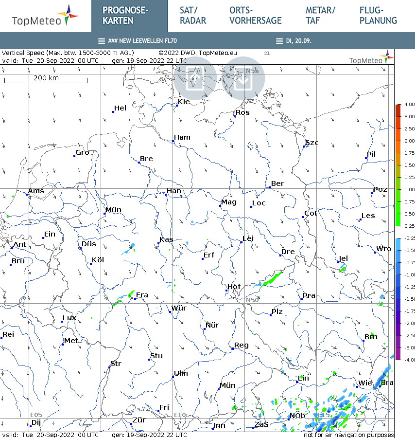
Mountain wave maps from TopMeteo show you where mountain waves can form and how they are likely to behave during the course of the day.
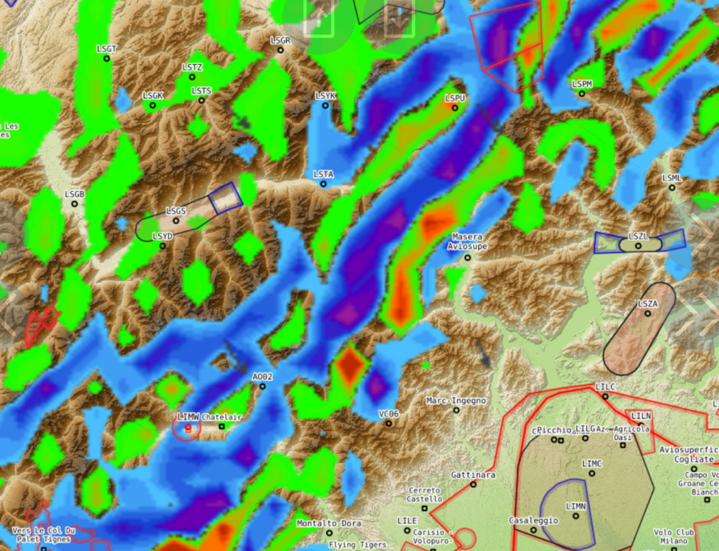
On the map shown, it is easy to see that when the winds are from the northwest, medium and high mountains indicate climb values that have a northeast-southwest orientation, such as the Ore Mountains on the border between Germany and the Czech Republic.
The predicted and current climb values are color-coded on the climb value scale (on the right side of the maps). In our example Erzgebirge, climb values between 0.25 and 0.50 m/s (green) are displayed – i.e. rather weak.
By clicking on the right arrow button (single arrow) you will move through the day by the hour. The double arrow to the right will take you further every day.
Wave gliding requires a little more intensive preparation in most cases. It is worthwhile to check the weather regularly and to keep an eye on the next 48 hours in order to take precautions if necessary (get the plane ready, get oxygen, start towing planes etc.).
How do I choose a wave flight route?
Another way to plan mountain wave flights is to analyze them based on your flight path.
To do this, go to the “Flight Planning” tab in TopMeteo and zoom in to a possible starting point (click on the map to select the point). The section in the example (Fig. 2) shows central Germany and the Harz Mountains. The green and blue colorations indicate that weak climb values are displayed on the lee side of the Harz mountains.
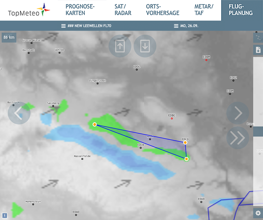
Glider pilots traveling in the surrounding area often use the Aschersleben airfield (EDCQ) as a takeoff point. If you are interested, just contact the airfield shortly beforehand – in most cases a group of wave flying enthusiasts has already been found and the towing machines are ready for takeoff.
After you have marked your starting point (EDCQ for Aschersleben) you draw your route accordingly along the waves you see on the map. Green colors indicate moderate climb values, orange and red are good to very good climb values. The second marked point would be your first turning point. For an FAI triangle you set the third point to your takeoff point – in this case again to the airfield Aschersleben. This is just one way to experience wave flying.
A possible route can be found quickly with the help of TopMeteo. Once you have decided on a route, you can download it as a .cup or .txt file or – with a TopMeteo subscription – export it as an LX.
How to find the climb values in the wave flight?
For aspiring mountain wave pilots, finding climb values can be a challenge, especially when climb areas are not marked by clouds.
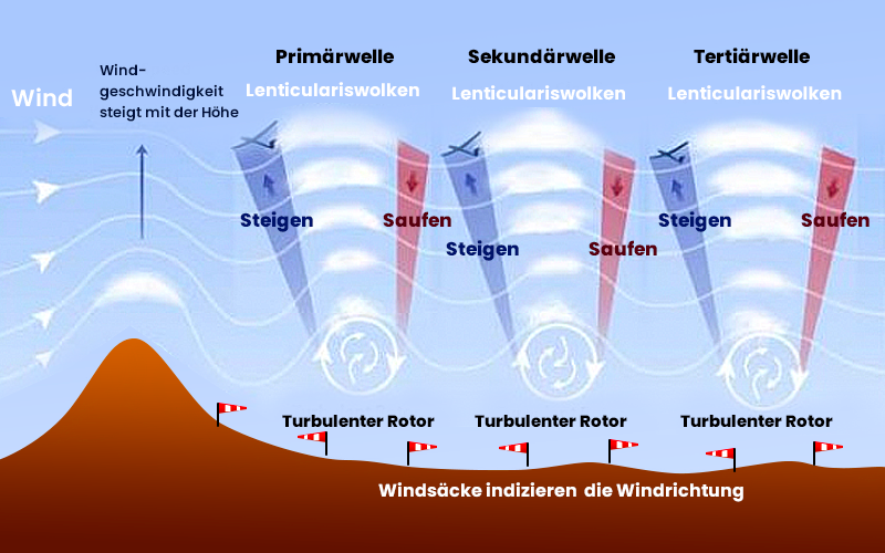
Image source: Brisbanehothairballooning.com
The graphic shows schematically where mountain waves occur The more indicators that fit, the more likely you are to fly to the right place and be prepared for downdrafts or rotors. It is important that the flow first falls into the depth. Only behind it do oscillations then arise.
Indicators can be:
- Stronger to strong wind speeds transverse to the ground elevation (e.g. mountains).
- Wind speeds increase with altitude: see TopMeteo mountain wave maps FL 70, FL 120, FL 170, FL 250
- Above the summit there are lenticularis clouds (possibly several on top of each other)
- parallel to the mountains are alternating cloud-free and lenticularis clouds. In front of the lentis (windward side) it rises, on the leeward side of the clouds it sinks
- Depending on the position, the windsocks or wind turbines are sometimes in the direction of the wind, sometimes in the opposite direction (rotor windward side, rotor leeward side).
It is best to join more experienced wave pilots and learn the first tips and tricks directly over the radio.
Each place has individual characteristics, which should be explained or shown by local pilots.
Here, the TopMetSat app gives you the wave up- and downwinds for the current hour and should be updated right before you start.
Fascinating wave flights
Why is wave flying so interesting?
There are two outstanding features that make wave flying so fascinating:
- In these wind systems you can reach flight altitudes of about 3000 to 8000 m (depending on airspace, weather and equipment). It is the only way to fly glider altitude world records, because thermal updrafts in the atmosphere are limited at altitude. For flights of this kind you need oxygen from about 3000 m and clothes that protect against the cold (the zero degree limit is around 3000-4000 m even in high summer).
Wave gliding often has its season in autumn, as the meteorological conditions (wind strength, wind direction) are most common in this season. You can extend your gliding season even further with wave gliding.
Exciting wave flying projects and inspiration
For all those interested in wave flying, a few exciting projects exist.
World records at breathtaking heights: The Perlan project
Probably best known is the Perlan project with the current research glider Winward Performance Perlan II (Greg Cole) which has already flown several records.
Vidcast with testimonials: Late Night Soaring
In the gliding vidcast “Late Night Soaring” you will find interesting experience and instructional reports that will bring you closer to wave flying.
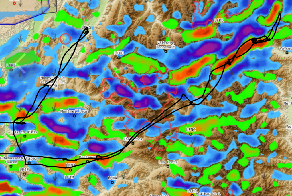
Skilled planning and execution: Thomas Puthod (FR) on 22.2.2022
Inspiration is always offered when other glider pilots and glider pilots are on the road.
A wonderful example of a successful wave flight is that of Thomas Puthod (FR) on February 22, 2022.
We have placed TopMeteo’s wave map under the flight file and can impressively see the flight path along the wave formations.
Let's go
Were we able to answer the first questions about flight weather preparation for wave gliding and to increase the interest once again?
Then let’s go!
The wave season is just around the corner.
For the optimal wave flight weather preparation: TopMeteo.